I had spent a couple of weeks meticulously planning a route through the Monadhliath for the Easter weekend. Mileage and ascent had all been taken into account to give me some realistic TGO Challenge training. However whilst just south of Glasgow on the drive up I changed my mind. Instead of starting from Loch Killin to the east of Loch Ness I decided on the easy option of a Garva Bridge start. It cut out a large chunk of driving, however it did mean heading into the hills without much of a plan. The Monadhliath are perfectly suited to this sort of aimless wandering though. As it turned out the change of plan was a good one. The high plateau was buried under deep snow making walking slow and tough. The long days I had planned would have been almost impossible.
The reason for a visit to this underrated part of the Highlands was to see a large area of wild land before it is buried under tonnes of steel and miles of new roads. Time for a stravaig through the site of the proposed Stronelairg wind farm before it is too late.
Image may be NSFW.
Clik here to view.
Map of whole route – a bit of a slackpack in the end!
There is room for several cars just before the historic Garva bridge. Strangely, although the Stronelairg wind farm has been consented SSE (the developer) have not done a great deal of thinking how they will connect it to the grid. A recent proposal is to build a large electricity substation close to this spot, right on the boundary of the Cairngorms National Park. Add this to the giant pylons for the Beauly Denny line plus new pylons to the wind farm and you have one ugly environmental fuck up.
If you ignore the towering pylons and the huge scar of the access track it is still a beautiful spot dominated by the towering snow-clad peaks of the Glenshirra Forest. Crossing the Spey I passed the last person I would see for five days. He was operating some sort of surveying equipment, no doubt a plan to build something else tall and monstrous.
I was glad to leave the industrialisation behind as I climbed alongside the Feith Talagain, the track soon becoming a narrow trod through the snow-covered heather.
Image may be NSFW.
Clik here to view.
Image may be NSFW.
Clik here to view.
I had to continue up alongside the river for a while before I could find a suitable spot to cross dry-shod. It was then a case of putting my head down and gritting my teeth on a tough climb through soft snow. This was not made any easier by carrying a heavy winter pack. At least the scenery gave me plenty of opportunities to stop and gawp whilst I got my breath back.
Image may be NSFW.
Clik here to view.
Image may be NSFW.
Clik here to view.
Image may be NSFW.
Clik here to view.
Image may be NSFW.
Clik here to view.
Image may be NSFW.
Clik here to view.
After the long drive and a slow ascent it was getting late by the time I reached the Corbett summit of Meall na h-Aisre. The air was crystal clear below a thick layer of cloud, the sun shining through in a halo of light. The snow was crisp to walk through at height, the cold wind nipping at bare skin. I looked down at the area I would be walking over the next few days. A vast high snow-covered plateau, the west coast Munro’s providing a jagged backdrop. It was sad to think that a wind farm the size of Inverness could soon be filling this wild land, the earth torn up for the many miles of access roads that will need to be built.
Image may be NSFW.
Clik here to view.
Image may be NSFW.
Clik here to view.
I descended north into this vast bowl, keeping east of the snow-covered and invisible Loch nan Sidhean. As I got lower the snow got softer and I would often find a leg disappearing up to the knee and occasionally up to the groin. It takes a bit of effort to extricate a fully buried leg when one remains above ground and with a pack on your back. Swearing seems to be the best way of getting out. I gingerly crossed the outflow of the loch which was buried under a drift of snow, snow bridges would be a common feature of the following few days.
I began to lose hope of finding a patch of ground that was either not covered in snow or frozen so solid that pegs would not penetrate. Finally a lumpy patch the size of a Trailstar was discovered and I wasted no time in erecting my shelter, fetching water from a mostly frozen stream and diving inside to get out of the wind.
Image may be NSFW.
Clik here to view.
Image may be NSFW.
Clik here to view.
I spent much of the night cursing the fact that I had brought the Trailstar, rather than a four season tent with a full solid inner. All started off well but after dark the wind picked up. This was initially ok as the wind was from behind and the Trailstar is bomb proof in wind, even when pitched high like I had it. The problem started when the snow began to fall. The snow came in the form of tiny sand like grains, the wind blowing it through the gap along the bottom edge. This would whip around and settle on the netting above my head, body heat melting it. I lay there dreaming of a nice cosy tent. There may be a Trailstar with Oookworks inner for sale soon.
Morning came with big fat wet flakes of snow as the temperature rose, this finally falling as rain. I had considered heading east to the headwaters of the Allt Cam nan Croc, a spot I had passed previously and which looked idyllic to camp. However with low cloud and deep soft snow the cross-country walk there would be more ordeal than pleasure. Instead I decided to head for the more sheltered confines of Glen Tarff.
The Allt Creag Chomaich was partially frozen in many places and completely covered in snow in others. I dismissed any thoughts of attempting to cross it, instead following the east bank to the security of the new hydro road.
Image may be NSFW.
Clik here to view.
Image may be NSFW.
Clik here to view.
I had seen the scar of this road in a previous visit but this time it was covered in snow, the surrounding landscape hidden under cloud. At least it prevented me from lurching from snow filled hag to tussock and I made reasonable progress through the eerie landscape to the new reservoir. This was also half-frozen, the wind pushing the ice floes towards the eastern shore.
Image may be NSFW.
Clik here to view.
Image may be NSFW.
Clik here to view.
I peeked through the windows of a building near the dam, the kettle, heater, table and chairs looking very inviting. The locked and very solid metal door prevented access and I had a snack shivering in the damp and cold instead.
The route down to the headwaters of the Tarff was as tricky as it looked on the map when you added in wet snow and low cloud. I slithered about for a while before finally picking up an old stalkers path into the shelter of the glen.
Image may be NSFW.
Clik here to view.
There I set up a basecamp as I decided that I would leave most of my gear the following day and head for a nearby hill. It was a damp and gloomy evening with a fine drizzle in the air. However I spent a much more comfortable night without snow filling my shelter!
The following morning I just packed some spare warm clothing, food and maps and set off down the glen on a narrow but well engineered path. It is obvious that it is now little used and it won’t be long before much of it is reclaimed by nature. Much of the snow had melted at this lower level, the burns crashing noisily down the hillside. Glen Tarff is a magnificent place, hidden and well off the beaten track of the nearby Corrieyairack Pass.
Image may be NSFW.
Clik here to view.
Image may be NSFW.
Clik here to view.
Image may be NSFW.
Clik here to view.
I climbed up the steep south western slopes of Carn Chuilinn, the summit being easy to find even in the snow and mist. A simple case of keep climbing until you get to the highest point. The walk east across the plateau however was anything but easy. With low cloud and the ground covered in snow my mind would play tricks, what I thought were towering cliffs would be a few boulders close by. It was difficult to judge distances and tell where the sky ended and the ground began. It did not help that the high plateau was dotted with numerous Lochans. All of them were completely frozen and most covered in snow. I was anxious not to accidentally walk across any of them. It was a very challenging hour or so and that was with the assistance of GPS mapping on my phone!
Image may be NSFW.
Clik here to view.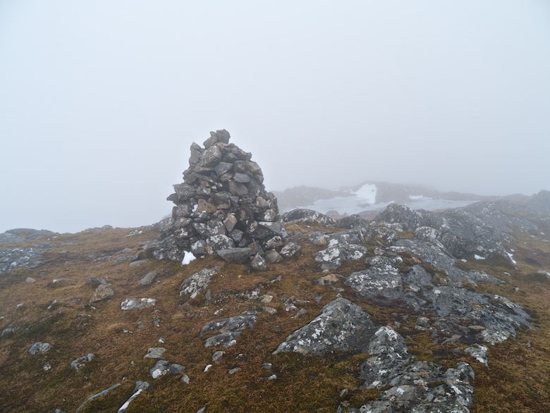
Image may be NSFW.
Clik here to view.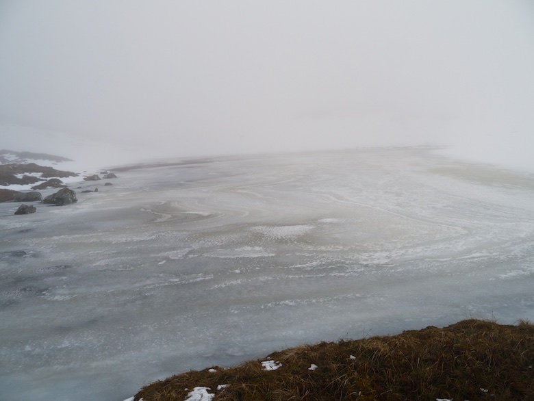
It was with relief that I managed to locate the outflow from Loch Carn a Chuillin, nervously crossed by a snow bridge. The river was in spate and would have been difficult to cross otherwise. Walking down back into the glen the sun put in a welcome appearance, a good omen for the following day when I would set back off across the plateau and hopefully a high level wild camp.
Image may be NSFW.
Clik here to view.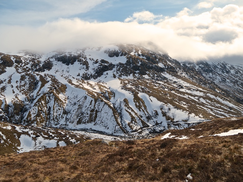
Image may be NSFW.
Clik here to view.
Image may be NSFW.
Clik here to view.
 Image may be NSFW.
Clik here to view.
